Go to Original Polish Text
Go to English Translation
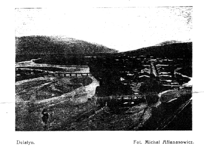
Lubiznia (56 km.) przystanek na przedmiesciu Delatyna, tuz obo wille dla letnikow. Za przystankium pierwszy z szeregu wspanialych, wysokich kamiennych wiaduktow, charakterystycznych dla tej linii (widok z lewych okien wagonu). Na lewo w dole widac Delatyn i doline Prutu.

Delatyn (58 km., 458 m.n.m.), do miasta 2 km., dorozka 1 K. 6200 m., w tem 600 P., 3100 R. i 2500 Z. Kolo dworca salina z duzym parkiem. Hotele Drimmera i Dickera. Restauracye Rummel i Stefaniuk. W wschodniej stronie miasta bardzo silne zrodlo solankowe z lazienkami mineralnemi; goscie kapielowi prawie wylacznie zydzi. Z urwiska nad lazienkami piekny widok na miasto. Wycieczka na Malawe (844 m., 1 1/2 godz.) z rozleglym widokiem na Doline Prutu, Beskidy Huculskie i Gorgany. W Luhu (5 km.) piekna cerkiew huculskiej roboty.
Od Delatyna zaczyna sie terytoryum zamieszkane przez Huculow.
Dora (63 km.) wies huculska i letnisko. Kolo dworca kilka will, wsrod nich hotel W. Lewickiego z restauracya. Wycieczki na Makowice. (987 m.) i Czarnohorzec (1402 m.), szczyt zawalony Gorganem; sciezka grzbietem polonin, 4 godziny.
Ilustrowany Przewodnik Po Galicyi. by M. Orlowicz.
Akademicki Klub Turystyczny We Lwowie; Lwow : 1914. pages 181 - 182
Lubiznia ( 56 km. ) In the suburbs of Delatyn, close to the summer cottages. After the stop, first in a row of magnificent, tall stone viaducts, characteristic for this railway line (view from the left window of the car). On the left into the valley one sees Delatyn and the Prut Valley.
Delatyn ( 58 km., 458 meters above sealevel ), 2 km. to town, horse carriage 1 Korona 6200 meters, into this 600 P., 3100 R. and 2500 Z. Near the railway station ______ with a large park. Hotels : Drimmer's and Dicker's. Restaurants : Rummel and Stefaniuk. On the eastern side of town there is a very powerful salt spring with a mineral bath; guests of the baths are almost entirely Jewish. From the cliffs above the baths there is a beautiful view of the town. Excursion to Malawe (844 meters, 1½ hours) With an extensive view of the Prut Valley, and the Hutsul and Gorgany Beskyds[3] . In Luhu ( 5 km. ) there is a beautiful Hutsul [2] -made church[1].
Beginning in Delatyn is the start of the territory inhabited by the Hutsuls [2].
Dora (63 km.) Hutsul[2] village and summer resort. Near the railway station are some cottages, among them is the Hotel W. Lewickiego with a restaurant. Excursions : to Makowice. (987 meters) and Chornohora[4] (1402 meters), summit covered with _______ ; ridge _______ , 4 hours.
Illustrated Guide to Galicia. by M. Orlowicz.
Academic Tourist Club of Lwow; Lwow : 1914. pages 181 - 182.
Polish differentiates between a "kosciol ", a Western (Protestant or Catholic) church, and a "cerkiew", or Eastern Byzantine-rite (Greek [Ukrainian] Catholic or Orthodox) church. The word here is "cerkiew".
Hutsuls are an East Slavic ethnic group. They are related to the Bojkos, Lemkos, and Sjans. The Hutsul language is part of the southwestern group of Ukrainian dialects along with Bojkian, Lemko, Transcarpathian, and Sjan.
Hutsul References in the Bibliography.
Hutsul and Gorgany Beskyds. An outer belt of the Carpathian Mountains composed mainly of sandstones, limestone and sandy shales is called the Carpathian Beskyds. The Hutsul Beskyd is to the east of the Prut River valley, and the Gorgany Beskyd are to the west of the Prut. The Gorgany form the most isolated region of the Ukrainian Carpathians.
The Chornohora ridge extends for 20 km to the southwest of Dora. Its peaks include Hoverla, Breskul, and Pip Ivan.