| GEOGRAPHY |
|
|||||||||||
|
INTRODUCTORY ESSAYS
REGIONAL Dimitry Feldman Chaim Freedman V.N. Nikitin Vlad Soshnikov TRAVEL |
A Journey in the Southern-Russian Jewish Colonies BY L.M.Bramson St.Petersburg 1894."I departed from Petersburg for the purpose of visiting the Jewish colonies in the south. The purpose of my journey was entirely clear to me. I wanted to acquire a visual perception of those places which had only been depicted in my imagination. I had read of them for a long time in books and newspapers and I wanted to see Jewish countryside, Jewish fields, to behold a Jewish economy, Jewish farmers and Jewish peasant children.
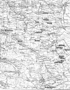
From Our Father's Harvest BY Chaim Freedman "The exact location of the Jewish Agricultural colonies in the Yekaterinoslav Government was a particular problem prior to the publication of the Our Father’s Harvest since they could not be identified on any map available at the time. A map was drafted based on the recollections of William Komesaroff of Melbourne as to the relative alignment of the colonies and the time required to travel by wagon between them.
BOOK REVIEW "Stalin's Forgotten Zion: Birobidzhan |
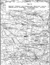
MICHOEL ROTENFELD DISCOVERS MAP
In 1983 a detailed large scale map was discovered in the library of the
University of Texas by Michoel Rotenfeld
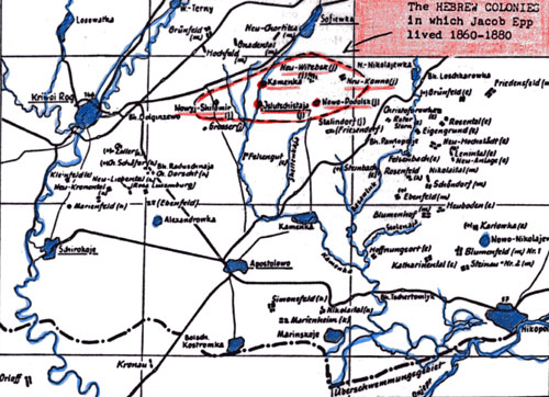
The Mennonite villages
Maps: Black Sea Area The Black Sea Settlements Prior to 1918 (Jonathan Sheppard map reprint) (Drawn in Germany to show location of the German settlements in southern Russia. Includes districts of Bessarabia, Chersson, Taurida, Jekaterinaslaw, Crimea and the western portion of the Don district. The map includes a key for identifying both the German and Russian settlements.) Maps: Jewish Agricultural Colonies of Ukraine
|
||||||||||

|
|
Research Contact: Chaim
Freedman
This page maintained by Max Heffler
Updated Thursday March 07 2024. Copyright © 1999 [Jewish Agricultural
Colonies of the Ukraine]. All rights reserved.