In 1983, a detailed large scale map was discovered in the library of the University of Texas by Michoel Rotenfeld whose family came from the region. This map was printed in 1955 in the USA by the U.S. Army Corp of Engineers, and was based on various Soviet maps as well as aerial intelligence photography.
It is suggested that you print this map and connect them to reproduce the map above.
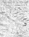 this is the left hand side of this large map described above.
Click on map to print.
this is the left hand side of this large map described above.
Click on map to print.
 this
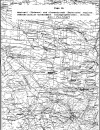
is the right hand side of this large map described above. Click on map to print.
this
is the right hand side of this large map described above. Click on map to print.
|
|
Research Contact: Chaim
Freedman
This page maintained by Max Heffler
Updated Thursday March 07 2024. Copyright © 1999 [Jewish Agricultural
Colonies of the Ukraine]. All rights reserved.