|
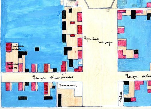
This map shows the western half of Rokiskis’ broad market square, which
is dominated at the western end by St. Mathews Church (top, center).
Entering the market square from the
left is “Kamai Street” (Ulitza Kamaiskaya, today, Respublikos gatvė)
On
the extreme left are two “Jewish schools” (“yevreiskaya shkola”).
The only words on this map are Russian,
written in Cyrillic script.
From 1864 until 1904, the Czarist
government forbade the use of the Latin alphabet in Lithuania.
West
South
+
North
→
East
This map is from the
archives of the Church of St. Matthew the Apostle and Evangelist in
Rokiskis.
Permission to use the map in this publication was graciously granted by
the parish deacon, Father Eimantas Novikas.
(Rokiškio
Švento Mato apaštalo ir evangelisto bažnyčios archyvams priklausantis
planas šiame leidinyje naudojamas gavus malonų minėtos bažnyčios klebono
dekano Eimanto Noviko sutikimą.)
All
rights reserved.
|