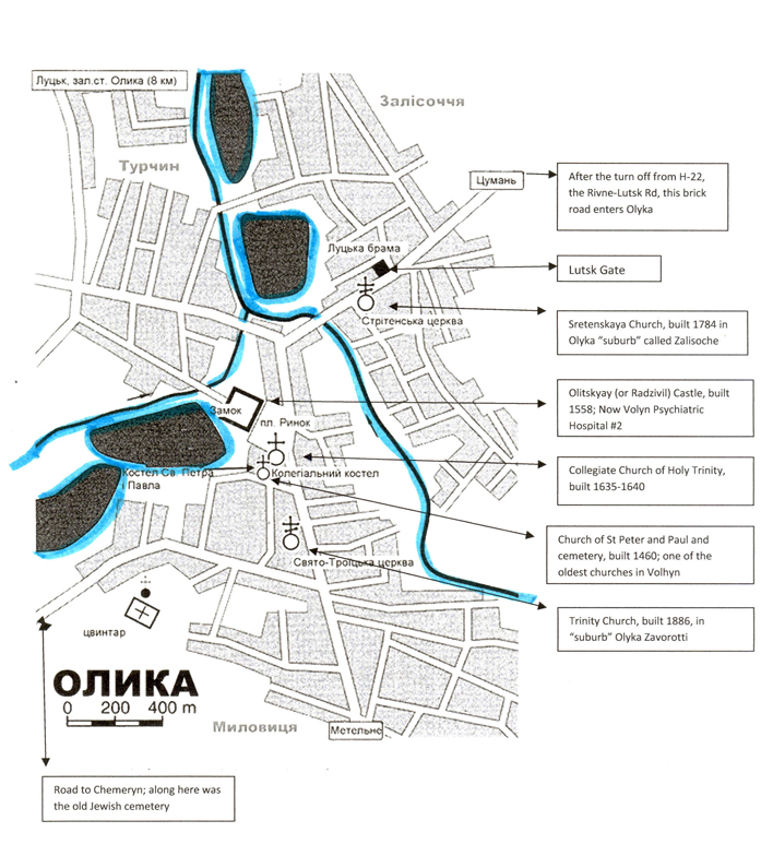
Mapping Olyka updated as of November 1, 2012
See map below.
Where is Jewish Olyka?
What we know:
The river cuts the town into 3 parts, though the town may be primarily below the Y convergence of the roads.
There are major landmarks in the town that have been there for hundreds of years which we can use as locators.
What we have gathered regarding locations:
1. The Jews lived on one side of the river, the Gentiles on the other (YB, p77, p74, Kramer)
2. The children from both sides would meet on the river to swim in the summer. (YB, p77)
3. When leaving home in Olyka to go to Lutsk, which is slightly north and west of Olyka,
townspeople would go along a river. At the end of town (Olyka) there was a windmill and
across the river was a brick factory. (Zuk )
4. There was an open space on the main road across from Radzivill Castle – this was the center
of town. (YB p 121)
5. Facing the church and the castle was the market with hundreds of shops (H. Kramer, New
Jersey- may be in an Ansky story as well)
6. The Olyker rebbe had a house in the center of town with a courtyard, a large house
surrounded by walls, a fruit orchard and horse stables (YB p 39)
7. There was a slight hill next to the “water institute” across the street from the Great
Synagogue (YB p 121)
8. The house of Papa Finkelstein-Cohen was next to the synagogue (YB p267)
9. The house of Papa Finkelstein-Cohen was across from a hill. The mailman would go to the
top of the hill to give out holiday greeting cards (YB p 267)
10. The Tailors Synagogue was attached to the Great Synagogue; the other synagogues were
also in the same small area (YB p 121)
11. The alley of Motel Glickman was a shortcut to the main road where there were stores. (YB
p267)
12. The Jewish Cemetery was out of town on the road to Chemeryn.
13. Srul Grinstein and family lived on Victory Street 2 blocks from the Putlikova River (Stein).
14. Along the main street (name unknown but TO212 on the map) was the Post Office, the Police Station, the Town Hall and the pharmacy as well as some homes. (Grinstein)
15. Victory St. was the name of the 1st street between the main road and the river in the period prior to WWII. The Water Supply Station and the Electric Supply Station were on this road. (Grinstein)
16. Berco Yoselevich St. was the name of the street between Victory and the river. It was a poorer area known as Ekdesh. The 7 synagogues were somewhere on this street as were the cheders. The town spa was nearby (Grinstein)
Places we need to locate on the map:
1. The big shul (this is the location of the old wooden shul that had been photographed extensively)
2. The “water institute” (if it exists from pre-WWII this would indicate where the Great Synogogue was located) and the hill next to it
3. The library and reading room
4. The high school (the Tarbut school was 2 stories tall YB p274)
5. Meshansky Road (the edge of town- home of Kreindel Melamed YB p 31)
6. The market and the animal market used on Olyka Fair Day, Wednesdays pre-WWII (YB p 32,
p 76) (The animal trading market was on the outskirts of town away from the main market
per Henia Gingberg)
7. Flour mills – 3 of them (all 3 were Jewish owned)
8. Beer factory (Jewish)
9. The rebbes courtyard and house
10. The mikveh/bath house
11. Rachel Gorbaty’s inn (where S. Ansky stopped on his travels)
12. The Holocaust Memorial
13. The Olyka Historical Museum at Hrushevsky str. 13
14. Kempa ravine (per Yad Vashem this is the major location where Jews were killed) |