Moscow Home Page
Moscow History
Pictures, Postcards
and Maps
Recommended
Reading
Family Stories
from Moscow
Emigration
Genealogical
Research
Databases
and Links
|
Maps, Pictures and Postcards of the Moscow Community
Maps
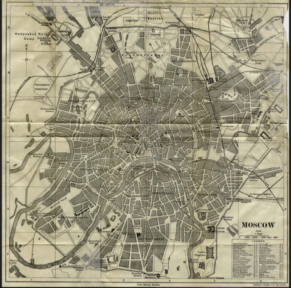
Moscow 1893
Digital Historic Moscow
"Old Maps of Moscow" provides multiple views of the city and its surroundings on
this website. Once located, a chosen place can be viewed on historic maps dating
from 1739 to the present, and the maps can be downloaded or printed. The website
is in Russian and English.
Europe 1815 to1905
Courtesy of the University of Texas Libraries, The University of Texas at Austin. Perry
Castaneda Map Collection.
European Railroad Routes 1891
Courtesy of David Rumsey Historic Map Collection. Zoomable, colorful, exact.
Moscow 1836
Moskvy Map by the Society for the Diffusion of Useful Knowledge, 1836. David
Rumsey Historic Map Collection. Zoomable, very clear. Legend is in English.
Moskwa City 1887
Map from Brockhaus Encyclopedia. Hic Leones Archive of Historical Maps. Very
clearly labeled, with separate alphabetical index. Legend is in German.
Moscow 1893
Moscow Map by John Murray, 1893 (Public Domain). Courtesy of the University of
Texas Libraries, The University of Texas at Austin. Perry Castaneda Map Collection.
Map of Moscow based on 1940 USSR map.
Published by the CIA. Courtesy of the U.S. Library of Congress. Zoomable, can be viewed in detail. Legend is in English.
Moscow 1980
Map of Central Moscow published by the U.S. Central Intelligence Agency 1980.
Zoomable, can be viewed in detail. Shows house numbering system, includes a street
index on a separate page. Courtesy of the Library of Congress.
Pale of Settlement 1905
Map from the Jewish Encyclopedia, 1905. In public domain, via Wikimedia
Commons from Wikimedia Commons
Russian Empire 1899
Courtesy of the New York Public Library.
Pictures and Postcards
Moscow River
1796 View of Kitai Gorod Wall and Zaryadye from the embankment. Watercolor.
Courtesy of Wikimedia Commons
1798 Moscow State University, Mokhovaya St.
Watercolor courtesy of Wikimedia Commons.
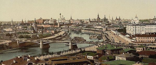
1868 Panoramic View of Moscow
Locations are explained in Russian. Photo courtesy of Wikimedia Commons.
1850 Varvarka St and Zaradaye with Chambers of Romanoff Boyars.
Watercolor. Courtesy of Wikimedia Commons.
1880 View of Zaryadye from Bell tower in Kremlin.
Postcard courtesy of Wikipedia.
Postcard courtesy of Wikimedia Commons.
1884 Kitai Gorod Wall and Zaraydye Quarter, viewed from the river.
Photo by N.A. Naidenov. Courtesy of Wikimedia Commons.
1886 Row of Storefronts in Varvarka St. Facing the Kremlin.
Photo by N.A. Naidenov. Courtesy of Wikimedia Commons.
1888 View of Varvarka St. in Zarayadye.
Photo by N.A. Naidenov, annotated in Russian. Courtesy of Wikimedia Commons.
1909 Sunday Jewish Market in Moscow
Courtesy of the U.S. Library of Congress
1909 Tenement in Pskovsky Lane, Zarayadye Quarter, Moscow.
Photo courtesy of Wikimedia Commons
Gate in Kitai-Gorod wall, Zaraydye.
Photo undated but taken prior to 1934, courtesy of Wikimedia Commons
|