![]()
![[Civic Coat-of-Arms]](images/Civic_Coat_of_Arms.jpg) | The Town of Belchatow
|

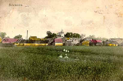
Postcard view of Belchatow (about 1914)
(Postcard provided by Martin Bornstein.)
Description:
Location: Belchatow is located in a section of central Poland that is part of the Southern Mazovian Heights, on the Rakowka River (a tributary of the Widawka), 23 km (14.3 mi) west of Piotrkow Trybunalski and 50 km (31 mi) south of Lodz. Present-day Belchatow covers an area of 3,464 hectares (8,560 acres). Currently (since 1999) it is in the Province of Lodz (lodzkie). Prior to that is was in the Province of Piotrkow Trybunalski (piotrkowkie). During the time of the czars (Kingdom of Poland; Congress Poland) it was located in the guberniya of the same name.
Climate and Resources: The average annual precipitation does not exceed 600 mm. Snow usually covers this town about 50 days of the year. The average temperature in January is -2.5 C°, and in July it is 18 C°. Much of the land is covered with forests and contains rich resources of brown coal (estimated at over 2 billion tons).
Nearby Jewish towns and villages: Grocholice, Kamiensk, Lask, Pabianice, Piotrkow Trybunalski, Radomsko, Rozprza, Sulejow (Silev), Sulmierzyce, Szczercow, Tomaszow Mazowiecki, Tuszyn, Widawa, and Zelow.
History of the Town:
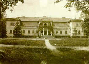
| Belchatow was first mentioned as a location in 1391. The Belchats founded and owned the town, hence the name. This noble family changed their name to Belchacki in 1405. The town changed hands several times. In 1617 the Kaczkowski family founded a church and built a wooden monastery, which was later given to the Franciscans. In 1670 a new brick church and monastery and a palace surrounded by a park were built by Stanislaw Rychlowki. Belchatow received the right to stage fairs and markets in 1737 and received a town charter in 1743. Factories were built and gave rise to the local textile industry. |
|
The Palace in Belchatow -- about 1905 |
After the second partition of Poland in 1793, Belchatow came under Prussian control and received an influx of settlers, including Jews. By 1820, when Belchatow ranked among the industrial centers of Poland, Jews constituted over half of the population. In the 1860 census conducted by the mayor Majewski, Jews numbered 1,139 (76%), Poles 325 (22%), and Germans 35 (2%). At that time there were two streets in the town, Pabianicka and Piotrkowska, and a main square, all unpaved. The town had received a city charter in 1843 but lost it in 1870, after the fall of the January Uprising, as a punishment for its active support of the insurgents. It then became the property of the German Reinhold Spiller and later the Hellwig family.
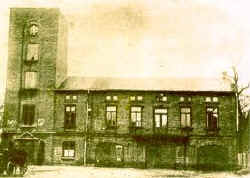
 The home of the fire brigade -- 1930 | In the early 20th century, the town continued to develop with new factories, a power plant, library, courthouse, bank, and new houses. The Voluntary Fire Brigade played a significant role in the consolidation of Polish society and in the maintenance of patriotic traditions. Polish was introduced as the language of instruction in schools in 1905. During World War I, the citizens of Belchatow took an active part in the struggle for Poland's independence. In 1925, when Poland was free again, Belchatow, considered a market town or a “settlement” ("osada" in Polish) until then, regained its municipal status and was once again elevated to the rank of city. In the first city elections held in 1925, 24 councilmen were elected, 13 of them Jews. The city council also had 5 people in official positions: 1 mayor, 1 vice-mayor and 3 aldermen. Two of the aldermen were Jews: Meir Warshawsky (a Zionist) and Shmuel Jakubovitch (representative of the artisans). |
Click here for a translation of the section on Belchatow from the 1929 Polish Business Directory Project of JRI-Poland in cooperation with JewishGen. It includes a list of Businesses and Industries ranging from doctor and banker to midwife and stall-operator at the weekly marketplace, each of which is followed with a list of names of the proprietors and merchants (both Jewish and Christian).
At the outbreak of World War II, in September 1939, the area around Belchatow bore witness to heavy defensive fighting (since Borowa Gora had the task of stopping the Nazi assault on Warsaw). During the Nazi Occupation, Belchatow was declared a Jewish town, since the Jews constituted nearly 50% of its population. The Nazis established a ghetto, where the Jewish people were brutally repressed, beaten, and murdered. The ghetto was closed in August 1942, when the remaining Jews were sent to the Lodz Ghetto or the Chelmno death camp. The town was liberated on 19 January 1945.
In January 1956, Belchatow was made the capital of a new administrative unit, or district (powiat).
Click here or "NEXT" at the bottom of the page for the History of Jewish Belchatow.
Map of the Town today:
City Plan of Present-day Belchatow
Click on map for a larger view (in Polish)
(NOTE: This file is large and may take a long time to download)
Click here for an
Interactive Map of Belchatow
(from the
official website for the town)
Map of Area:
Hold your cursor over the map below to see a more detailed view of the area within the square.
View Belchatow via Map Quest (Latitude 51º 22', Longitude 19º 23').
Or look at the area via the Interactive map of Poland (mostly Polish)
Links:
Official Website for Belchatow (English translation) -- and see its interactive virtual walk around present-day Belchatow and its gallery of historical photographs. | |
|
Andrzej Selerowicz's
website of old Belchatow,
which contains an
interactive street map
of buildings and Jewish homes in Belchatow around 1900. | |
|
The Lexicon of Polish Cities, Towns, and Villages (English) |
History of Poland with a brief outline of Poland's history from 966 to the current times on the Embassy of Poland in Ljubljana's website. |
Photos of Current-day Belchatow
| |
|
Postcards of Current-day Belchatow
|
This page last revised
May 28, 2009.

![[map of Belchatow city plan]](images/city_plan.jpg)
![[map of Belchatow area of Poland]](images/MapquestBelchatow.gif)