|
|
Jewish Cemetery in Rozhnyatov |
|

|
|
Jewish Cemetery in Rozhnyatov |
|
Description of the 1944 photograph and the 2000 map
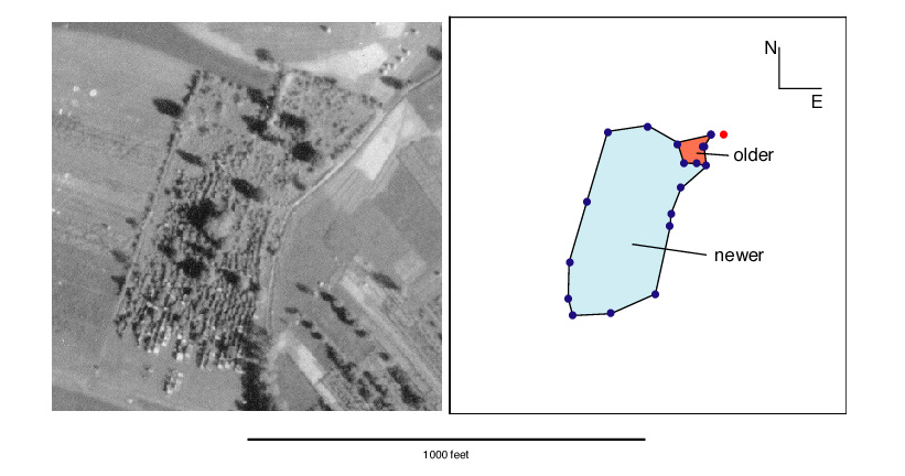
Below is a comparison between an aerial reconnaisance photograph (left) taken by the German Air Force on July 4, 1944 and a map of the cemetery (right) made with a Global Position System (GPS) receiver by Thomas F. Weiss, Aurice Weiss, and Alexander Dunai during a visit to the cemetery on September 19, 2000. The scales of each figure were determined independently. The scale for the photograph was obtained from NARA and was 1:13,000. The scale for the map was obtained by using the latitude and longitude readings of the GPS receiver and creating a map from these readings by a method that is described elsewhere. Both the outlines of the photograph and the map are square and the sides represent a distance of 1000 feet. In the photograph, a region can be seen in the northeastern part of the cemetery (upper right hand corner ) that is enclosed and is separate from the rest of the cemetery. In the map, the northeastern portion of the cemetery is shown shaded in red. Inspection of the site at the time the map was made indicated that this was the older portion of the cemetery and it was separated from the rest of the cemetery by an embankment of earth. The newer part of the cemetery is shaded light blue in the map. The points on the map are the sites of GPS readings of latitude and longitude along the perimeter of the cemetery in 2000. The red dot is the reference location and has the coordinates: latitude 48°56.721´N; longitude 24°9.252´E and an elevation of 1138 feet.

Comparison of 1944 photograph and 2000 map
First, note that the general shape and orientation of the cemetery are similar in both the map and the photograph despite the fact that they were determined independently with no adjustment of any parameters. The similarity in orientation suggests that the German aircraft that took the photograph had its camera oriented close to due north. However, if the scales of both the photograph and map are correct, then it is clear that the dimensions of the Jewish cemetery in Rozhnyatov is substantially (25-30%) smaller in 2000 than it was in 1944.
| Comparison of the map and photograph also suggests that the proportion of the older portion to the newer portion is much smaller in the map than in the photograph.To compare the relative size of the older to the newer portion of the cemetery in the photograph to that in the map, the map (yellow outline and blue points) has been superimposed on the photograph (on the right). The photograph has been reduced in size by 75%. The alignment of the photograph and map is arbitrary although only translations were done, but it is clear that older portion of the cemetery is a smaller fraction of the whole cemetery in the map of 2000 than it was in the photograph of 1944. |
|
Interview in the cemetery
On September 19, 2000 while we were mapping the cemetery we met a 75-year old Polish lady, named Rosalia Yagelovitch Rebega, who was working in a field that adjoined the cemetery. Her family has owned the lot adjoining the cemetery since before the WWII. Among other things, she said that there had once been many marble stones in the cemetery that have been stolen. She also said that the cemetery used to be much larger and once had a wooden fence around it.
Conclusion
Although there are remarkable similarities between the 1944 German photograph and the 2000 map, there are also important differences. The area of the cemetery in the 2000 map is at least 25% smaller. Also, the proportion of the older portion of the cemetery is reduced a disproportionately larger amount.
There are many possible reasons for the differences between the 1944 photograph and the 2000 map. For example, the scale for the photographs may be wrong. It seems unlikely that the accuracy of the GPS readings are responsible. In view of the history of cemeteries in the former Galicia, it seems most likely that the cemetery in Rozhnyatov is not intact and has suffered considerable attrition. It also appears that the older portion of the cemetery has suffered a greater reduction than the newer portion.