|
|
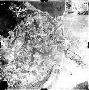
World War II German Flown Aerial Photograph
Defense Intelligence Agency, Record group 373
Kobyl'nik GX735 SD exposure #019
![]()
A brief description
Main Source: Yosef Sa'ar
![]()
NARACH
Located at 54'56" 26'41", 79.7 miles NNW of Minsk, in Minsk Oblast.
Alternate names: NAROCH, KOBYL'NIK, KOBYL'NIKI.
KOBYLNIK was originally (Minori Medalo) "Little Myadel" in 1434. Officially it has been NAROC as part of the Union of Soviet Socialist Republics in the 1950's. However, on a 1994 German map it was still called Kobylnik. Russian is the local language both written and spoken.
To get to the cemetery, go to the only crossroads in town and
turn east. Travel about two km. Pass some small wooden houses to a small wood
about 150 meters south of the road.
 A dirt road leads to the gate of the
cemetery. Zosia Dergatch who lives a short path to the main street visits
regularly. A priest living nearby is entrusted with overseeing the Jewish
cemetery affairs as a representative of Meir Svirsky, an Israeli engineer. Mr.
Svirsky, formerly of that town near the Lithuanian border, has paid to fence off
the cemetery, put in iron gate, and place a memorial tablet.
A dirt road leads to the gate of the
cemetery. Zosia Dergatch who lives a short path to the main street visits
regularly. A priest living nearby is entrusted with overseeing the Jewish
cemetery affairs as a representative of Meir Svirsky, an Israeli engineer. Mr.
Svirsky, formerly of that town near the Lithuanian border, has paid to fence off
the cemetery, put in iron gate, and place a memorial tablet.
Yosef Sa'ar visited this cemetery and found no listing of persons interred there. Many of the gravestones are in bad condition. It would probably be next to impossible to decipher even half of them. He did, however, find the stone of an Asher Hayyim HADASH, died about 1917.
North of the village and just east of the highway is a fenced off area and plaque marking the site of the murder of the local Jews by the Germans in W.W.II.
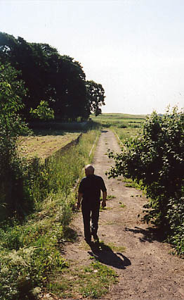
Picture from Postov Street looking down the small path to the cemetery on the
left of the path. Small River to the viewers' right of the path under the big
trees.