A Part of Life in Zurawno
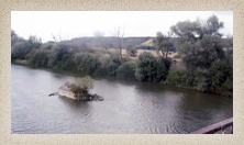
The Dniester (pronouced "nee'-ster") is the second longest river in the Ukraine, originating in the Carpathian Mountains near the city of Drohobych and continues for 845 miles (1,360 km) before emptying into the Black Sea. It also forms the boundary between Ukraine and Moldova.
Long ago the Dniester was considered so important that Galicia was sometimes referred to as Naddnistrianshchyna, or "Land by the Dniester." However, the river's fortunes were closely tied to political events. Its value declined after the Tatar invasions of the 13th century, and also during the 16th century when Moldavia was under Turkish rule. While many towns relied upon the Dniester for transportation, water and food, it never achieved the shipping volume of the Dnieper.
Zurawno was built near the banks of the Dniester, Swiczy and Krechowa rivers. In May and June of 1915 the Germans and the Russians fought over control of the Dneister near Zurawno, with the Germans emerging victorious.
According to a personal recollection by a former resident of Zurawno, the Dniester river was used by the residents, "especially the young people," in the summer to bathe, swim and relax. There was a small boat, called a parom, that ferried passengers across the river.
Another account mentions that people fished, cut down trees and hunted rabbits. A bridge spanned the river near Zurawno, but it was destroyed during World War I. The bridge was rebuilt in 1931, but the roads around it were in poor condition and prevented its widespread use. In the 1930s, Jewish youth had a sailing club near the river. And in 1941, the river overflowed and flooded the surrounding area. Crops were destroyed, and Jews were forced to barter their valuables for a few kilograms of flour or potatoes.
Additional information about the Dniester River:
Encyclopedia of Ukraine
Wikipedia: Dniester
The New York Times, 1915