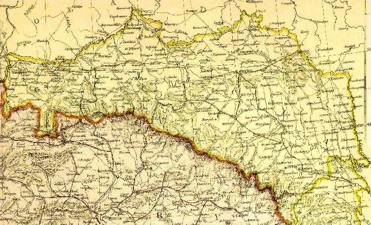
Galicia: What It Was and What It Looked Like on an Early Map
Galicia--an extensive mountainous area that included the northern slopes of the Carpathian Mountains and the valleys of the upper Vistula, Dniester, Bug, and Seret rivers.
In 1772, under Austrian rule, the province, Galicia, is the given name to that partition of Poland which was occupied by the Austro-Hungarian Empire between 1772-1918.
The full name of the province was "Galizien und Lodomerien" in German, or [Galicia et Lodomeria] in the Latinized form. The name is derived from two ancient duchies, Halychyna and Volhynia, which served as buffer states between the southeastern Polish frontier and the Kievan State, until their absorption by Poland in the 14th century.
The province stretched like a crescent moon from Krakow in the west, to the Romanian border in the southeast, following the northern slopes of the Carpathian Mountains. It had a population of over 7 million people in 1900, consisting mainly of Catholic Poles in the western third; Orthodox Ruthenians in the eastern third; and a mixture in the middle; and large German and Jewish communities scattered throughout. After World War I and the Russo Polish War 1920-21, the province returned to Polish administration. However, after World War II, the Soviet Union forced the annexation into the Ukraine of all but the overwhelmingly Polish areas. Many Poles were expelled, and the traditional, the mainly Polish, capital of Lwow (Lemberg) was brutally Russianized.
The province which since the late 1700's is known as Galicia is one of the historical regions of Poland, especially its western part (west of the San River), traditionally called Malopolska, i.e. Little Poland (as opposed to Greater Poland around Poznan). Its most important city, Kraków has long been the seat of Polish kings. The eastern part of Galicia was previously called Ruthenia and originally inhabited by Ruthenians (now split into Ukrainians and Belarussians). Due to the Polish influence since the 14 century more and more Poles settled in Ruthenia and also many Ruthenians adopted the Polish language and culture.
During the Partitions of Poland in 1772 and 1795 the Austrian Empire annexed Little Poland and Ruthenia. The Austrians invented a name Galicia for these new areas (in 1815, northern regions of it were ceded to Russia and became part of the Kingdom of Poland dependent on Russia). Between 1815 and 1846 the city of Kraków together with a small surrounding area was a quasi-independent Republic of Kraków. In 1846 this territory was incorporated into Galicia (thus becoming part of Austria). In the 19th century, about 50% of the Galician people were Polish Catholics, who were the majority in the western districts and about one-third in the eastern regions. 40% of the inhabitants, mostly in the eastern part, spoke Ukrainian and were Byzantine Catholics. The Jewish minority (about 10%) lived mostly in towns. A small German minority was also present.
The Austrian Government was benevolent to Jews, and by 1868 Galicia's Jews had attained equal status under the law. Austria did little, however, to further economic development in Galicia.
Before WW I ,the Jews in Galician villages and towns were retailers or craftsmen especially in the household industry (as tailors, furriers, and hatters. The export and import trade of the region was mainly in the hands of Jews, as the transit between Turkey and Russia in the East and Germany in the west centered in Brody.
After WWI, the territory of Galicia became part of independent Poland. During WWII, the Nazis murdered most of the Jewish inhabitants of the province. After the war, the former Galicia was divided between Poland and Ukraine (within the Soviet Union). Most of the Poles living east of the new border re-settled to Poland, whereas the Ukrainian-speaking population of the territories which remained Polish were either expelled to Ukraine or dispersed to other parts of Poland.(3)
|


