


Lubaczów, Poland
50° 10' N/ 23° 08' E
|

Other names: Libatchov, Libechuyv, Liubachev, Lubachov, Lubatchov, Lubichuv
|
| |
| Maps |
| |
Finding Lubaczów on a present day map of Poland:
Look for Przemysl in the southeast corner of Poland, close to the
Ukrainian border.
Lubaczow is situated 50 km NNE of Prezmysl , just where the two
rivers Lubaczowka and Solotwa meet.The Lubaczow river then continues west
north, goes into the Vistula river and ends up in the Baltic Sea.
Google Map of Lubaczow
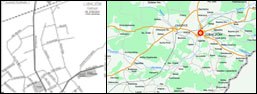
(Click to enlarge)
In 1931 Lubaczów had 6,261 citizens: 2,319 Poles, 2,145 Ukraines, 1,794 Jews, one German, and two Czeck.
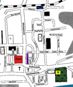
Map of Lubaczów,
1917

(Click to enlarge)
This map was made a few years after the railroad was built.
Map of Galicia 1882
by FEEFHS
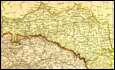
(Click to enlarge)
Map of Lubaczów,
1997
(Click to enlarge)
Map of the Rynek area
3D model of the Rynek area
created by Barak Floersheim
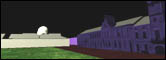
(Click to view 3D model)
My son created the 3D model in an attempt to get a feeling of being in the
Rynek; this despite the fact that we have not yet visited Lubaczów.
He constructed the 3D model from old postcards.
The 3D model is in VRML format (*.wrl)
Attention: If the 3D model won't appear after pressing the link above (you see just coding text instead of a 3d model) then you will have to download and install a VRML plug-in in your system. I recommend downloading and installing the "Cosmo Player" plug-in.
KehilaLinks Directory | JewishGen HomePage
| |
© 1999-2001 Site Design by Barak Floersheim,
All Rights Reserved
Last Updated 19 Oct 2024
|
| |
|

