Kosava is located at 52º 45′ 29″ N, 25º 9′ 16″ E (decimal degrees: 52.7580556, 25.154444) placing it in present-day Belarus.
Modern Map
This map shows current-day Kosava. As described below, some of the features (2 churches and a Christian cemetery) from the interwar map can be found on this modern map.
Period Maps
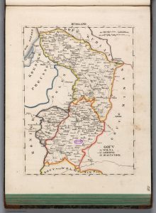
Kosava was situated towards the western edge of the Russian empire. This map, from 1829, shows its location in the Grodno Governorate (gubernia). It is labeled “Koszow” and has been circled with a purple oval to assist locating it. (Click to see an enlarged version.) The original map, available from the David Rumsey Collection, can be enlarged further.

Starting in 1919, the Polish Military Geographical Institute (Wojskowy Instytut Geograficzny or “WIG”) set out to produce a comprehensive collection of maps of Poland. They faced many challenges because the previous divisions of the nation, but the benefit (to us, in the historical perspective) is that they completely remapped the entire country in detail. The web site mapywig.org provides scanned maps from the interwar period with relevant information in both Polish and English. The following links to downloadable high-resolution scans are particularly relevant:
- A 600-dpi scan of a 1:25,000 map of Kosów Poleski from 1932.
- A 400-dpi scan of a 1:25,000 map of Choroszcza from 1932. It shows the area immediately to the east of Kosava, in particular an area known as “Kolonie Kosów”
- A 300 dpi scan of 1:100,000 map of the area around Różana from 1935. This map is in color and shows a much larger area, including Kosów Poleski.
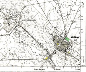
At the end of the Polish-Soviet War much of the territory of modern Belarus was ceded to Poland and was mapped in the 1930s. The area around Kosava was extracted from one of the 1:25,000 maps and some features have been tinted, below. The text following the map explains the shading used.

The Jewish cemetery, subsequently destroyed and described in further detail in the Religious section, was located in the area shaded green in this map.
Two Christian churches are marked in yellow, as is a Christian cemetery to the southwest of the town center. These can also be located on the modern map of Kosava, Belarus.
