 |
Panemunė (Aukštoji Panemunė, Lithuania) |
A History of Panemune
By Rabbi Jeffrey
A. Marx
July, 2021
Historical Outline of Sovereignty Over
Panemune
1400s- Panemune
in territory of Grand Duchy of Lithuania.
1569‑ Panemune
in territory of Kingdom of Poland. (Wojewodztwo
1765- Panemune
in territory of Kingdom of Poland, Powiat
1795‑ Panemune
in territory of New East Prussia, Bialystok
1807‑ Panemune
in territory of Duchy of Warsaw, District of
1815‑ Panemune
part of Uznemune (area along the left bank of the
1837‑ Panemune
in territory of Congress Poland, Augustow Gubernia.
(Polish administration under Russian sovereignty).
1866/67‑
Panemune in territory of Privislansky Kraj (Land of the Vistula),
Suwalki Gubernia, powiat (district) Mariampol, Gmina (township)
of Ponemon-Pogaiskoy. (Russia).
1874- Panemune
in territory of Suwalki Gubernia, Suwalki
Uyezd (district).
(Russia).
1908- Panemune
in territory of Suwalki Gubernia, Uyezd Mariampole.
(Russia).
1915- Panemune
in Suwalki Gubernia (Germany).
1918‑ Panemune
in territory of New East Prussia.
(Germany).
1919- Panemune
in territory of Lithuania.
(Lithuania).
1931- Panemune
incorporated as a suburb of Kaunas. (Lithuania).
1940‑ Panemune
in territory of Lithuanian Soviet Socialist Republic.
(Russia).
1941‑ Panemune
in territory of Generalbezirk Litauen, Administrative
Province of Reichs Kommissariat Ostland. (Germany).
1944‑ Panemune
in territory of Lithuanian Soviet Socialist Republic.
(Russia).
1990‑ Panemune
in territory of Republic of Lithuania.
(Lithuania).
Introduction
Panemune means,
in Lithuanian: "On the Niemon River."
It is located on the left (west) bank of the Niemon, Southeast and
across from Kaunas, between the mouth of the Jiesia and the Nemunas dam, in
an area known as Uznemune (left bank area of the Niemon.)
A loop of the Neimon surrounds it on three sides.[3]
Early History
In the 14th
Century, Panemune was part of the Grand Duchy of Lithuania and was the site
of a castle. According to one
theory, Vietotus, Grand Duke of Lithuania, sought help from German knights
to fight against Jaghello, king of Poland.
He permitted the knights to build several castles on the bank of the
Niemon river, one of which was built on what is now upper Panemune.
Another theory suggests that in 1396, Vietotus destroyed a castle
which had been built there.[4]
In the late
1400's, the high hill at the southwest end of Panemune, was owned by Zev,
the son of Daniel of Troki, who lived in Kaunas.
It was later known as "Jido Kelnis": "The Mountain of the Jews."[5]
The estate of
Panemune was established in 1559.[6]
Over the centuries it grew into a berg as merchants settled there and
custom officials moved in, who imposed dues on cargo ships navigating the
Niemon.[7]
In 1569, Panemune became part of the Polish-Lithuanian Commonwealth,
a merger between the Polish Kingdom and the Grand Duchy of Lithuania.[8]
In the 18th Century, Panemune was the property of Simanui Siruciui,
an elder of the Kaunas Court, who built a stone church there in 1762/63.
In 1763, Panemune was granted city rights.
In 1794, Siruciui's grandson, Karolis Prozoras, donated all of his
wealth to aid in the Kościuszko Uprising against Russia and the Kingdom of
Prussia, and sold Panemune to Petrui Lebrechtui Frencesliui.
It then became known as Frentcelio Panemune/Panemune Frentzele.[9]
In 1795, as part
of the third partition of the Polish-Lithuanian Commonwealth, Russia seized
territory on the east side of the Niemon, which included Kaunas, and Prussia
seized territory on the west side, including Panemune.
The area seized by Prussia was
now known as "Neu‑Ost‑Preussen" (New East Prussia).
Panemune served as the Township
seat, situated in the Powiat (district) of Mariampole, in an administrative
area called, “The Bialystok Department”.[10]
In 1799, Panemune had 844 inhabitants.[11]
In January,
1807, Napoleon seized New East Prussia (and in 1809 seized Austrian
territory to the south), and called this new conquered area, "The Grand
Duchy of Warsaw." The Niemon
River remained its boundary on the east.[12]
Panemune continued to be in the Bialystok Department and probably
continued to be part of the district of Mariampol.
In June of 1812,
Napoleon began the war against Russia from the bank of the Niemon River in
Panemune. He directed the
invasion against Kaunas from the top of a high hill in Alexota, just to the
West of Panemune. On the night of June 23d, 300 soldiers were ferried across
the Niemon to serve as a protective screen for the thirty army engineers who
built three pontoon bridges across the Niemon; two of which were between
Panemune and the Jasia River which emptied into the Neimon. The next
morning, soldiers from the Polish 6th Uhlan (lancers) Regiment
who had occupied Panemune, were the first to cross, followed by the rest of
the invading forces, some 200-250,000 men, over the course of two days.[13]
Some of the remnants of the Grand
Army also passed through Panemune again, on their retreat.[14]
As a result of Napoleon’s defeat in 1813, Russia occupied the Duchy of
Warsaw, which included Panemune.
In 1815,
following the Congress of Vienna, Russia incorporated the territory west of
the Niemon, which included Panemune.
The new area was called, Kongresowka: "The Congress Kingdom of
Poland." It was a Russian
dependency, internally governed by Poles.
Panemune, together with Kaunas, became part of the Voivodeship
(province) of Augustow.[15]
In 1825 the city
rights were revoked.[16]
In 1831, during the Polish rebellion, a group of uprisers, led by
Colonel Dembickius briefly took over Panemune.
(City rights were reinstated in 1837.)
Following the 1831 rebellion, the Polish Voivodeships were replaced
by Gubernias (provinces).
Panemune was now located in Augustow Gubernia, while Kaunas, across the
river, was the center of Kaunas Gubernia.[17]
In the
mid-1800s, some of the land around Panemune was owned by Herr Leopold von
Ashfort, a German nobleman.[18]
In 1859, a second church (made of brick) was built there.[19]
By this time, Panemune was the Township seat (Gemin).[20]
On December 19th, 1866, Panemune became part of the Suwalk Gubernia,
Mariampole Powiat (county), Ponemon-Pogaiskoy Gemin.[21]
In 1868, Panemune vital record documents switched from Polish to
Russian.[22]
In 1868-69 was a severe famine in Suwalk Gubernia, known as "the
great hunger", as well as a cholera outbreak, which spurred emigration from
Panemune.[23]
By 1884, the 4th Fort, part of a ring of eight forts that encircled
Kaunas, was built in Panemune.[24]
In order to build the fort, the Russian government pressured
Frentcesliui’s descendents to sell Panemune.[25]
Some of the land in the late 1880s was owned by the Tur family.[26]
Panemune, in 1897, had 1,575 inhabitants.[27]
In the early
1900s, Panemune was a popular resort area.
In 1912/1913, an airport was build in Panemune by the Czarist army
for the defense of the western
border of the Empire.[28]
From 1915 to 1918, Germany seized Congress Poland.
In 1916, the German army built a temporary bridge connecting Panemune
with Kaunas.[29]
In 1918, Panemune became part of independent Lithuania.
In 1921, a military school was moved there and an officer's school
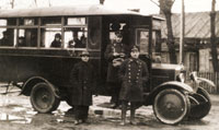
was established. In 1924, bus
service was instituted between Kaunas and Panemune.[30]
By 1928, a more
permanent bridge had been built, linking Panemune
with Kaunas.[31]
In 1931, Panemune became a western suburb of Kaunas.
In 1932 it had 3,700 inhabitants.
In 1940 Panemune
was now in the territory of the Lithuanian Soviet Socialist Republic and
was, once again, a Russian dependency.
From 1941-1944, as a result of German occupation, Panemune was in the
territory of Generalbezirk Litauen, Administrative Province of Reichs
Kommissariat Ostland. In 1944
Panemune was, once again, in the territory of the Lithuanian Soviet
Socialist Republic under Russian domination, which was to continue until
1990 when the area became part of the Republic of Lithuania.
ENDNOTES
[1]
(See
File 824, "Panemune", Lithuanian Communities Collection, YIVO, N.Y.)
[2]
Variants, most of which are found in the Ellis Island Database,
include: Panaman, Panamun, Panamin, Panemon, Panemun, Panemune,
Panemune Frentzele, Panemuni, Panemunyje, Panomon, Panyemun,
Peinemon, Penemin, Pojnemun, Ponemon, Ponemony, Poniaman, Poniemon,
Poniemun, Ponjemon, and Ponomin.
[3]
(See
Encyclopedia Lithuanica, "Aukstoji Panemune"; Troy, Abraham,
Surviving the Holocaust: The Kovno Ghetto Diary, Harvard
University Press, 1990, pp. 20,89,maps). Panemune’s coordinates are
54* 51’ Latitude; 23* 58’ Longitude.
[4]
(See
Encyclopedia Lituanica, Vol. IV, "Aukstoji Panemune".)
[5]
(See
Yahadut Lita, Vol. III, quoting the Lithuanian Metrica.)
This high hill was later called Mt. Napolean.
[6]
(See
Encyclopedia Lituanica, Op. Cit.)
The expansion was possibly due to the influence of King
Sigmund I (1507-1548) who encouraged trade and craftsmanship.
Under his protection, the population of Kaunas grew.
It was during this time that Polish and German merchants were
settling in Kaunas, as well.
(See Freidheiman,
Peisach, "Epilogue Instead Prologue", Gyvenimas ir Atmintis:
Kauno Zyd ai nuo 1944-uju, Kaunas, 1994, p. 37).
Exactly what the boundries of Panemune were, is currently
unknown. Whether
Panemune encompassed the area known in the 20th Century as,
Patemulshelis, is not clear.
[7]
“In this period, there was a significant growth in the export of
flax, grain, live fowl, cattle, milk products, and wood, which were
floated down the Neimon and its tributaries.
Of particular importance was the water route from Kovno to
Riga (via Keidan and Shavli) and the overland route from St.
Petersburg to Warsaw, which also passed through Kovno.”
(Dov Levin, The Litvacks, op. cit., p. 25).
[8]
“The
Commonwealth was governed by a parliament of nobles, who elected
both a Grand Duke for Lithuania and a King of Poland.”
(Landsmen, Vol. 12, nos. 1-2, July 2002, p. 27.)
[9]
See Encyclopedia Lituanica, Op. Cit.; Supplement to
HaMagid, Feb. 7th, 1872, lists the town of “Ponemon Frenzil”;
“Exhibition city Kaunas: Plans and Maps”
(1/31/2015 at WWWMaps4U.Lt/en/news.php?page_id=62) shows “Poniemon”
appearing in a 1776 map made by
Prussian topographers.
[10]
What
the relationship, communication and trade were like between Panemune
and Kaunas during the next 15 years is unknown, though
a 1795 map of the Nemunas River, now serving as the border between
Russia and Prussia, shows some type of bridge stretching from the
Panemune area (not identified) around border marker #177, to Kovno,
as does a 1795-1800 New East
Prussia military map and a 1800 Plan of city Kaunas.
(“Exhibition city Kaunas:
Plans and Maps”, Op. Cit.).
[11]
(See
Wasicki, Jan, Prussian Descriptions of Polish Towns From the End
of the 18th Century: Bialystok Department, Adam
Mickiewicz University, Poznan, 1964.
This is based on Prussian archive data complied by August
Carl von Holsche in 1799-1800; Landsmen, Vol. 12, Nos. 1-2, July,
2002, pp. 5 and 14).
[12]
While Panemune’s side of the Niemon was now under the Napoleonic
Code, and thus used the new-style calendar, the Kaunas side of the
Niemon continued to employ the Russian civil calendar.
Thus, the bridge from Aleksota to Kaunas was jokingly called
the longest in the world, since the trip across it resulted in a
change of 12 days.
(“Kaunas Dates and Facts”, Op. Cit.).
[13]
“Finally we came to the Memel River, where the Russian border was.
The town of Poniemon was located there.
Everyone rejoiced to see the Russian boundary at last.
We encamped at the foot of the hill this side of the river…
The town of Poniemon was already stripped before we could enter…”
(Jakob Walter, The Diary of a Napoleonic Foot Soldier, Marc
Raeff, edit., Doubleday, 1991, p. 41, based on, “A German Conscript
with Napoleon-Jakob Walter’s Recollections of the Campaigns of
1806-1807, 1809, and 1812-1813”, Otto Springer editor and
translator, Bulletin of the University of Kansas-Humanistic Studies,
vol. VI, nu. 3, 1938). “With the points…of his own army group held
back and out of sight from the opposite river bank, Napoleon
exchanged the gray overcoat he usually wore for a Polish hussar’s
cloak and rode along the Niemen to make a personal reconnaissance
and to finalize the exact locations where the bridges were to be
laid down.” (Richard K.
Riehn, 1812: Napoleon’s Russian Campaign, McGraw-Hill
Publishing Co., NY, 1990, p. 162). "His reconnaissance completed, he
gave the order that the following nightfall three bridges should be
thrown over the river near the village of Poniemen...” (Napoleon's
Russian Campaign, translated and edited by Townsend, J. David,
1958, Houghton Mifflin Co., Boston, abridged version of La
Campagne de Russie, Memoires d'un Aide de Camp de Napoleon, de
Segur, Count Philippe-Paul, Nelson, Paris, 1824, pp. 5,7.) The
cavalry first went over on June 24th, followed by the
rest of the army on June 25th.
(Jakob Walter, Op. Cit., p. 41, Riehn, Op. Cit., pp.
163-164). He spent part of the day in his tent and part in a nearby
Polish mansion, lying without energy in the breathless, muggy
heat...Perched on the highest hill, about three hundred feet from
the river, we saw the Emperor's tent." (Napoleon's Russian
Campaign, Op. Cit.). This was, in all probability, the high hill
once owned by Zev, the son of Daniel of Troki. (See above).
Several maps of the 20th Century label this spot as
"Napoleon's Hill", as do the inhabitants of Panemune to this day.
(See 1914-1919 Russian map of the
Western Frontier, “Exhibition city Kaunas: Plans and Maps”, Op.
Cit., that shows Napoleon’s Hill, in an area called Jessia, between
Ponjemon and Freda on the Nemun River.
Wolf
Bregstein letter to Jeff Marx, 17th, April, 1990.
See also photo, ca. 1905,
bfc‑00382, Boris Feldblyum collection, which shows a house on the
right bank of the Niemon in which Napoleon allegedly stayed, and see
photo of house, below) .
[14]
Under
the command of Murat, following the final destruction of the French
army at Paneriai, the remnants of the French army retreated through
Kaunas on Dec. 9/10, 1812.
(See The Cambridge Modern History, Vol. IX, Macmillan
Co., NY, 1906, pp. 490-505).
"It was not without some difficulty that we climbed the
almost perpendicular slope which one must surmount on leaving Kovno
for Mariampol."
(Decaulaincount, p. 275).
“From Vilna onward, the Russian cavalry again sufficed to
chase the French across the Niemen.
Ney attempted to hold the bridge at Kovno…” (Riehn, Op. Cit.,
p. 394). Other of Napoleon’s soldiers crossed near-by.
“By the end of December, we reached the Polish border along
the Memel River. When I
heard that it would be very hard to get through near Kovno, I led my
horse up the river and crossed...” (Jakob Walter, Op. Cit., p. 96).

15th-16th Century House Where Emperor Napoleon Was Said to Have
Stayed on December 7, 1812
(Photo
by P. Karpavičius, Kauno architektūra,
Vilnius,1968.
Courtesy of Kaunas County Public Library)
[15]
None-the less, a number of the French regulations remained in force
in this area. (See Shea, Jonathan, "Kongresowka- The Kingdom of
Poland", in Landsmen, Vol. 3, numbers 2-3, 1992-93, p.21; and
Dov Levin, The Litvaks, op. cit. , p. 27).
[17]
Again, the fact that Poniemon and Kovno were in two different
Gubernias probably did not effect day to day life.
1837/38, 1850 and 1871 Plans of City Kaunas, show a bridge from the
Panemune area to Kaunas.
(“Exhibition city Kaunas: Plans and Maps”, Op. Cit.).
[18]
(See Horwich, Op. Cit., p. 11‑13.)
A German cemetery was in existence, just outside of Panemune,
up till the end of WWII.
[19]
(See
Encyclopedia Lituanica, Op. Cit.)
[20]
(See
Encyclopedia Lituanica, Op. Cit.)
[21]
Suwalk
Gubernia was formed from the old Augustow Gubernia. (See
1993 letter from Lithuanian State Archives to Philo
Bregstein).
[22]
Civil
registration first began in 1808, using Polish.
Following the unsuccessful Polish uprising in 1868, the
Russian government decreed that vital records be kept in Russian.
(See Jeffrey K.
Cymbler, "Polish-Jewish Genealogical Research- A Primer", Avotaynu,
Vol. IX, number 2, Summer 1993, p. 7.)
(See 1829 death
record for Hirsha Bregshtein written in Yiddish and Polish, in
Panemune death registry, 1826-1837; 1878 Judith Bregstein birth
record in Kovno birth registry, 1842-1902, written in Yiddish and
Russian.) Judel
Bragsten's 1875 Swedish application to Vista i Riket, however,
contains supporting documentation from the rabbi of Panemune written
in Polish, suggesting that while Russian may have been required for
civil documents, Polish was still the preferred choice at that time.
[23]
(See
Suwalki Yizkor Book; and Dov Levin, The Litvaks, op. cit., p.
82). An earlier famine
had also occurred in 1843-1845.
(See Dov Levin, The Litvaks, op. cit., p. 28).
It may also be that the establishment of a railroad station
in Kaunas, in 1863, made travel easier across Lithuania. ("Kaunas
Dates and Facts", Op. Cit.).
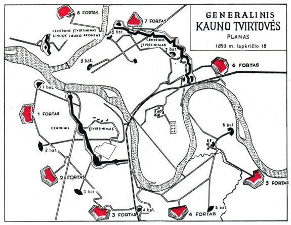
General Plan of the Fortress System
(Mokslas ir gyvenimas,1969, nr. 3, p. 8)
Courtesy of Kaunas County Public Library
[25]
(See Encyclopedia Lituanica, Op. Cit.; Independent
Suwalk & Vicinity Benevolent Association and Relief Committee,
Op. Cit.). There are
several factors which may have led to this. In the aftermath of the
Second Rebellion against Russian rule, (1863), a program of
Russification was intensified. “... Russian officers and aristocrats
inherited the estates of those Lithuanian noblemen who had
participated in the rebellion.”
(Dov Levin, The Litvaks, p. 28).
Could it be that Frentcesliui was more than “pressured”?
Also, the second half of the Nineteenth Century saw an intensive
program of military construction, such as the fortresses around
Kovno. (Dov Levin,
The Litvaks p. 28).
[26]
They
owned 539 acres. (See
Sulimierski, Op. Cit., "Poniemun", #6.)
[27]
(See
Jewrejskaja Enciklopedia (Jewish Encylopedia}, 1897 and
“Suwalk Gubernia”, Evrejskaya Entsiklopediya, St. Petersburg,
1906-1913, Vol. IX, pp. 339-341.)
[28]
“Kaunas Dates and Facts (Kaunas Public Library,
http://datos.kvb.lt/en/index.php?option=com_laikotarpiai&task=view&id=19&Itemid=65).
[29]
“Kaunas Dates and Facts” (Kaunas County Public Library,
Http://datos.kvb.lt/en/index.php?option=com_laikotarpiai&task=view&id=21&Itemid=67&extend=190&highlight=bridge#i190).
1914-1919 Russian map of the
Western Frontier shows a bridge, called Eisenhart, from Ponjemon to
Kovno. 1917 Plan of city
Kaunas, ("Plan
von Kowno und Umgebung", publisher Kownoer Zeitung) also shows a
bridge from Ponjemon to Kovno. (See
“Exhibition city Kaunas: Plans and
Maps”, Op. Cit.).
[31]
(“Kaunas Dates and Facts”, Op. Cit.).
The bridge was partially destroyed by an ice drift in the
spring of 1928 and was rebuilt by the end of Dec. of that year.
In June of 1941, the withdrawing Soviet army destroyed the
bridge. It was
rebuilt on the old supports in 1957.
Web Page: Copyright © 2009-2021 Jeffrey A. Marx