
G e o g r a p h y
 Giraltovce is a shtetl in north-eastern part of Slovakia.
Has today 4271 inhabitans.
Giraltovce is a shtetl in north-eastern part of Slovakia.
Has today 4271 inhabitans.
It is situated on the stream Radomka and near the river Topla 24 km north-east of Presov.
It is 210 m above the sea level. The coordinates are: 4907N 2131E. Postal code: 08701.
P o l i t i c a l h i s t o r y
The first written testimony about Giraltovce originated in 1416.
The nobles from Drienov initiated the settlement of a group of villages : Valkovce, Matovce, Fijas, Francovce and Giraltovce in the 14th century.
"Obecny dom" 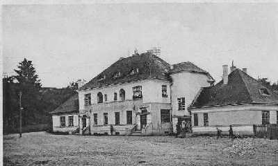 - includes notary, tax and post offices. In the 1930's Bela
Lustbader the notary and Freimann, head of the tax office occupied the official flats.
- includes notary, tax and post offices. In the 1930's Bela
Lustbader the notary and Freimann, head of the tax office occupied the official flats.
Click here to obtain enlarged picture.
Until 1918 this region was a part of the Austro-Hungarian empire. From then until the
Munich agreement in September 1938 it became a part of the Czechoslovakian Republic. On
March 14, 1939 the Slovakian State was proclaimed . In 1945 the Czecho-Slovakian Republic
was back till 1993, when this state came apart and was divided into two states : The
Czech and the Slovak Republics.
Last updated May 12th, 2009