Street DirectoryIntroduction to the 1925 Anykščiai Property Owners Directory & Street Map by L. ChiltonBackgroundDuring the German army's occupation of Lithuania in World War One, a Lithuanian conference was allowed to convene in Vilnius to elect a governing council. The newly-elected body quickly adopted a resolution demanding the restoration of Lithuanian independence from Russia. In 1918, independence was declared and a seimas (parliament) was formed. In 1922, a Lithuanian parliamentary republic was declared and a new constitution was adopted. A priority of the new Lithuanian government was the revamping of jurisdictions and boundaries and the replacement of Russian place names and nomenclature with Lithuanian equivalents. In addition to the remapping and renaming of cities, towns and villages, it was necessary to conduct a census in order to establish current property ownership following the massive dislocations of WWI, especially of the Jews.On June 8, 1925, a plan to establish the boundaries of Anykščiai and the naming or renaming of its streets was presented at an Anykščiai district council meeting and approved by district chief, M. Sauciulis (Protoc. no. 1 § 3). Data derived from a street census of property owners were used to create a hand-written property owners list and a hand-drawn property owners street map. (Both documents were subsequently deposited with the Architectural Engineering Institute in Vilnius along with similar documents from other cities, towns and villages.)Creating a New Database: The 1925 Anykščiai Property Owners Directory In 1998, at the International Association of Jewish Genealogical Societies (IAJGS) annual conference in Los Angeles, California, fellow Aniksht landsman and Jewishgenner, Selma Jackson, brought a copy of a 1925 list of names and a street map of Anykščiai that she had acquired during a trip there in 1996. The 1925 list, which enumerated Anykščiai property owners by street and house number, had been photocopied many times. The same was true of the map. The copies I received from Selma were murky and hard to read. Discouraged by their condition, unable to read the author's small, hand-written scrawl and ignorant of the Lithuanian language, I set the list and map aside and all but forgot about them.In 2009, I picked them up again and with a 10X eye loupe began studying each one in earnest. After a few months of scrutiny, with translation assistance from Vitalija Gircyte of the Kaunas Regional Archives in Lithuania, I was able to create a printed document of the list that records the street names and many of the property owners, but only for the central core of Anykščiai. During my research, I soon learned that the list I was working from was incomplete. I acquired a second list which largely overlapped the first one in coverage but nevertheless added an additional 15-20 percent more names. Although still incomplete, it is fortuitous that most of the Jewish population was concentrated in the central part of town which is well represented on the list. I call this new, cumulative list the "1925 Anykščiai Property Owners Directory."Making Sense of the 1925 Anykščiai Property Owners DirectoryUpon reviewing the names in the Directory, the reader will notice that the Jewish neighborhood, i.e., the shtetl Aniksht, was largely segregated from Lithuanian Anykščiai, but some mixing did occur. No doubt, Jews also lived and owned property entirely outside this area and a number of their Lithuanian neighbors are shown to have owned or occupied property within Jewish Aniksht.It should be underscored that the names listed in the directory were the owners, not necessarily the tenants, but, in most cases, they were probably one and the same. Some owners' names appear more than once, an indication that they owned more than one piece of property and were, therefore, relatively prosperous. They may have lived in one residence and rented out another, or owned a property while living in another town or village. (Today, we might refer to these property owners as "absentee landlords.") Also, a number of addresses show no ownership, or missing owners.Making the Directory More UsefulAfter creating a readable, albeit incomplete, 1925 Anykščiai Property Owners Directory, I painstakingly compared its readable names with those associated with Anykščiai in the LitvakSig All Lituania Database (ALD), the JewishGen Lithuania Database (derived mainly from the ALD), and Yad Vashem's Pages of Testimony database. This comparison of names proved highly successful. Excluding multiple entries of the same property owner, approximately 65 percent of the legible Jewish names in the Directory were found in the online databases.When a name in the Directory was recognized in one or more of the databases with a reasonable degree of confidence, the Directory name was footnoted and the information from the database(s) was listed in a corresponding endnote. Family names in the Directory that were recognized in Yad Vashem's Pages of Testimony database were identified in the endnotes with a Magen David ( ). The 1925 Anykščiai Property Owners Street MapThe original map, like the original property owners list, is difficult to read and lacks the features of a proper map. Structures are depicted by a small box with an accompanying number and sometimes a religious symbol. They correspond to the street numbers and religious institutions on the list. With the assistance of Vitalija Gircyte, who helped with the street names, and cartographer Robert Provin of California State University, Northridge, California, Dept. of Geography, I performed a modest redraft and identified most of the streets. It's still more of a sketch than a proper map but serves the purpose. By using the Street Map in conjunction with the Directory, you may be able to identify an ancestor's property or dwelling. If you have success, please tell us about it on the LitvakSig Digest or the JewishGen Discussion Group. Finally, it should be noted that the Anykščiai street map of 1925 and a street map of today are very different. Changes following WWII and again in 1990 resulted in new streets being laid out, old streets being rerouted or renamed, and house numbers often changed. Finding one's ancestral home, even if it's still standing, could present a challenge. 1944 German Aerial Reconnaissance Photographby L. ChiltonBackgroundThe Nazi invasion of the Lithuanian Soviet Socialists Republic began on June 22, 1941 and reached Anykščiai on June 27th. The German occupation of Lithuania officially ended on January 28, 1945. In the interim, approximately 96 percent of Lithuanian Jewry were brutally murdered.In Hamburg, Germany at the end of the war, the U.S. Army captured more than 1.2 million German-flown aerial reconnaissance photos. The Cartographic and Architectural Branch (CAB) of the U.S. National Archives at its facility in College Park, Maryland, holds these images, which are part of Record Group (RG) 373, Records of the Defense Intelligence Agency. Three of these images are of Anykščiai and have been given the following order numbers: GX1471 SD10 (taken July 22, 1944), GX1458A SD145 (taken July 22, 1944), and GX633 SD71 (taken July 29, 1944). (Because there is some overlap between these aerial photos, it is possible with the proper stereo viewing device to see parts of Anykščiai in 3-D and to make height and size estimates of manmade and natural features - a skill once used by air photo interpreters and now done with satellites and computers.)The best of these three images (GX1458A SD145) was scanned at high resolution, then substantially cropped in size to approximate the area covered by the 1925 Anykščiai Property Owners Street Map, so that the reader can make direct comparisons of the two.Interpreting the Aerial PhotographIn this aerial photo of Anykščiai taken at an undisclosed altitude by German Luftflottenkommando 1, Stabsbildabteilung (Air Force Command 1, Picture Division Staff), on a sunny morning on July 22, 1944, what are we able to interpret from it? We see what appears to be a column of vehicles in Baranausko Square and along Skemoniu Street. Since it is unlikely they are civilian automobiles, they must be military vehicles. But are they German or Soviet? To try to answer this question, we must look at all available historical information. The date of the photo, July 22, 1944, places it on the cusp of the Soviet reoccupation of the Baltic States, which began in the summer and autumn of 1944. The fact that the German air force took the photo suggests that it was conducting aerial surveillance of advancing Soviet forces. Or could the vehicles in the photo be retreating German ground forces? We don't presently know, but of one sobering fact we can be sure: on the day this photograph was taken, few if any Jews were still alive in the once thriving shtetl that our ancestors knew as Aniksht. StreetsOpen the 1944 German Aerial Photograph of Anykščiai 1944 Aerial PhotoOpen the 1925 Anykščiai Street Map (To be used in conjunction with the 1925 Anykščiai Property Owners Directory)1925 Street MapOpen the 1925 Anykščiai Property Owners Directory1925 Property Owners


 Street Directory
Introduction to the 1925 Anykščiai Property Owners Directory & Street Map
by L. Chilton
Background
During the German army's occupation of Lithuania in World War One, a Lithuanian conference was allowed to convene in Vilnius to elect a
governing council. The newly-elected body quickly adopted a resolution demanding the restoration of Lithuanian independence from
Russia. In 1918, independence was declared and a seimas (parliament) was formed. In 1922, a Lithuanian parliamentary republic was
declared and a new constitution was adopted.
A priority of the new Lithuanian government was the revamping of jurisdictions and boundaries and the replacement of Russian place
names and nomenclature with Lithuanian equivalents. In addition to the remapping and renaming of cities, towns and villages, it was
necessary to conduct a census in order to establish current property ownership following the massive dislocations of WWI, especially of the
Jews.
On June 8, 1925, a plan to establish the boundaries of Anykščiai and the naming or renaming of its streets was presented at an Anykščiai
district council meeting and approved by district chief, M. Sauciulis (Protoc. no. 1 § 3). Data derived from a street census of property owners
were used to create a hand-written property owners list and a hand-drawn property owners street map. (Both documents were
subsequently deposited with the Architectural Engineering Institute in Vilnius along with similar documents from other cities, towns and
villages.)
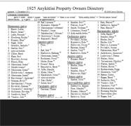
Creating a New Database: The 1925 Anykščiai Property Owners Directory
In 1998, at the International Association of Jewish Genealogical Societies (IAJGS) annual conference in Los Angeles, California, fellow
Aniksht landsman and Jewishgenner, Selma Jackson, brought a copy of a 1925 list of names and a street map of Anykščiai that she had
acquired during a trip there in 1996. The 1925 list, which enumerated Anykščiai property owners by street and house number, had been
photocopied many times. The same was true of the map. The copies I received from Selma were murky and hard to read. Discouraged by
their condition, unable to read the author's small, hand-written scrawl and ignorant of the Lithuanian language, I set the list and map aside
and all but forgot about them.
In 2009, I picked them up again and with a 10X eye loupe began studying each one in earnest. After a few months of scrutiny, with
translation assistance from Vitalija Gircyte of the Kaunas Regional Archives in Lithuania, I was able to create a printed document of the list
that records the street names and many of the property owners, but only for the central core of Anykščiai. During my research, I soon
learned that the list I was working from was incomplete. I acquired a second list which largely overlapped the first one in coverage but
nevertheless added an additional 15-20 percent more names. Although still incomplete, it is fortuitous that most of the Jewish population
was concentrated in the central part of town which is well represented on the list. I call this new, cumulative list the "1925 Anykščiai
Property Owners Directory."
Making Sense of the 1925 Anykščiai Property Owners Directory
Upon reviewing the names in the Directory, the reader will notice that the Jewish neighborhood, i.e., the shtetl Aniksht, was largely
segregated from Lithuanian Anykščiai, but some mixing did occur. No doubt, Jews also lived and owned property entirely outside this area
and a number of their Lithuanian neighbors are shown to have owned or occupied property within Jewish Aniksht.
It should be underscored that the names listed in the directory were the owners, not necessarily the tenants, but, in most cases, they were
probably one and the same. Some owners' names appear more than once, an indication that they owned more than one piece of property
and were, therefore, relatively prosperous. They may have lived in one residence and rented out another, or owned a property while living
in another town or village. (Today, we might refer to these property owners as "absentee landlords.") Also, a number of addresses show no
ownership, or missing owners.
Making the Directory More Useful
After creating a readable, albeit incomplete, 1925 Anykščiai Property Owners Directory, I painstakingly compared its readable names with
those associated with Anykščiai in the LitvakSig All Lituania Database (ALD), the JewishGen Lithuania Database (derived mainly from the
ALD), and Yad Vashem's Pages of Testimony database. This comparison of names proved highly successful. Excluding multiple entries of
the same property owner, approximately 65 percent of the legible Jewish names in the Directory were found in the online databases.
When a name in the Directory was recognized in one or more of the databases with a reasonable degree of confidence, the Directory name
was footnoted and the information from the database(s) was listed in a corresponding endnote. Family names in the Directory that were
recognized in Yad Vashem's Pages of Testimony database were identified in the endnotes with a Magen David ( ).
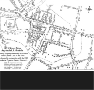
The 1925 Anykščiai Property Owners Street Map
The original map, like the original property owners list, is difficult to read and lacks the features of a proper map. Structures are depicted by
a small box with an accompanying number and sometimes a religious symbol. They correspond to the street numbers and religious
institutions on the list.
With the assistance of Vitalija Gircyte, who helped with the street names, and cartographer Robert Provin of California State University,
Northridge, California, Dept. of Geography, I performed a modest redraft and identified most of the streets. It's still more of a sketch than a
proper map but serves the purpose.
By using the Street Map in conjunction with the Directory, you may be able to identify an ancestor's property or dwelling. If you have
success, please tell us about it on the LitvakSig Digest or the JewishGen Discussion Group.
Finally, it should be noted that the Anykščiai street map of 1925 and a street map of today are very different. Changes following WWII and
again in 1990 resulted in new streets being laid out, old streets being rerouted or renamed, and house numbers often changed. Finding
one's ancestral home, even if it's still standing, could present a challenge.
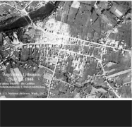
1944 German Aerial Reconnaissance Photograph
by L. Chilton
Background
The Nazi invasion of the Lithuanian Soviet Socialists Republic began on June 22, 1941 and reached Anykščiai on June 27th. The German
occupation of Lithuania officially ended on January 28, 1945. In the interim, approximately 96 percent of Lithuanian Jewry were brutally
murdered.
In Hamburg, Germany at the end of the war, the U.S. Army captured more than 1.2 million German-flown aerial reconnaissance photos. The
Cartographic and Architectural Branch (CAB) of the U.S. National Archives at its facility in College Park, Maryland, holds these images,
which are part of Record Group (RG) 373, Records of the Defense Intelligence Agency.
Three of these images are of Anykščiai and have been given the following order numbers: GX1471 SD10 (taken July 22, 1944), GX1458A
SD145 (taken July 22, 1944), and GX633 SD71 (taken July 29, 1944). (Because there is some overlap between these aerial photos, it is
possible with the proper stereo viewing device to see parts of Anykščiai in 3-D and to make height and size estimates of manmade and
natural features - a skill once used by air photo interpreters and now done with satellites and computers.)
The best of these three images (GX1458A SD145) was scanned at high resolution, then substantially cropped in size to approximate the
area covered by the 1925 Anykščiai Property Owners Street Map, so that the reader can make direct comparisons of the two.
Interpreting the Aerial Photograph
In this aerial photo of Anykščiai taken at an undisclosed altitude by German Luftflottenkommando 1, Stabsbildabteilung (Air Force
Command 1, Picture Division Staff), on a sunny morning on July 22, 1944, what are we able to interpret from it? We see what appears to be
a column of vehicles in Baranausko Square and along Skemoniu Street. Since it is unlikely they are civilian automobiles, they must be
military vehicles. But are they German or Soviet?
To try to answer this question, we must look at all available historical information. The date of the photo, July 22, 1944, places it on the cusp
of the Soviet reoccupation of the Baltic States, which began in the summer and autumn of 1944. The fact that the German air force took the
photo suggests that it was conducting aerial surveillance of advancing Soviet forces. Or could the vehicles in the photo be retreating
German ground forces? We don't presently know, but of one sobering fact we can be sure: on the day this photograph was taken, few if any
Jews were still alive in the once thriving shtetl that our ancestors knew as Aniksht.
Streets
Street Directory
Introduction to the 1925 Anykščiai Property Owners Directory & Street Map
by L. Chilton
Background
During the German army's occupation of Lithuania in World War One, a Lithuanian conference was allowed to convene in Vilnius to elect a
governing council. The newly-elected body quickly adopted a resolution demanding the restoration of Lithuanian independence from
Russia. In 1918, independence was declared and a seimas (parliament) was formed. In 1922, a Lithuanian parliamentary republic was
declared and a new constitution was adopted.
A priority of the new Lithuanian government was the revamping of jurisdictions and boundaries and the replacement of Russian place
names and nomenclature with Lithuanian equivalents. In addition to the remapping and renaming of cities, towns and villages, it was
necessary to conduct a census in order to establish current property ownership following the massive dislocations of WWI, especially of the
Jews.
On June 8, 1925, a plan to establish the boundaries of Anykščiai and the naming or renaming of its streets was presented at an Anykščiai
district council meeting and approved by district chief, M. Sauciulis (Protoc. no. 1 § 3). Data derived from a street census of property owners
were used to create a hand-written property owners list and a hand-drawn property owners street map. (Both documents were
subsequently deposited with the Architectural Engineering Institute in Vilnius along with similar documents from other cities, towns and
villages.)
Creating a New Database: The 1925 Anykščiai Property Owners Directory
In 1998, at the International Association of Jewish Genealogical Societies (IAJGS) annual conference in Los Angeles, California, fellow
Aniksht landsman and Jewishgenner, Selma Jackson, brought a copy of a 1925 list of names and a street map of Anykščiai that she had
acquired during a trip there in 1996. The 1925 list, which enumerated Anykščiai property owners by street and house number, had been
photocopied many times. The same was true of the map. The copies I received from Selma were murky and hard to read. Discouraged by
their condition, unable to read the author's small, hand-written scrawl and ignorant of the Lithuanian language, I set the list and map aside
and all but forgot about them.
In 2009, I picked them up again and with a 10X eye loupe began studying each one in earnest. After a few months of scrutiny, with
translation assistance from Vitalija Gircyte of the Kaunas Regional Archives in Lithuania, I was able to create a printed document of the list
that records the street names and many of the property owners, but only for the central core of Anykščiai. During my research, I soon
learned that the list I was working from was incomplete. I acquired a second list which largely overlapped the first one in coverage but
nevertheless added an additional 15-20 percent more names. Although still incomplete, it is fortuitous that most of the Jewish population
was concentrated in the central part of town which is well represented on the list. I call this new, cumulative list the "1925 Anykščiai
Property Owners Directory."
Making Sense of the 1925 Anykščiai Property Owners Directory
Upon reviewing the names in the Directory, the reader will notice that the Jewish neighborhood, i.e., the shtetl Aniksht, was largely
segregated from Lithuanian Anykščiai, but some mixing did occur. No doubt, Jews also lived and owned property entirely outside this area
and a number of their Lithuanian neighbors are shown to have owned or occupied property within Jewish Aniksht.
It should be underscored that the names listed in the directory were the owners, not necessarily the tenants, but, in most cases, they were
probably one and the same. Some owners' names appear more than once, an indication that they owned more than one piece of property
and were, therefore, relatively prosperous. They may have lived in one residence and rented out another, or owned a property while living
in another town or village. (Today, we might refer to these property owners as "absentee landlords.") Also, a number of addresses show no
ownership, or missing owners.
Making the Directory More Useful
After creating a readable, albeit incomplete, 1925 Anykščiai Property Owners Directory, I painstakingly compared its readable names with
those associated with Anykščiai in the LitvakSig All Lituania Database (ALD), the JewishGen Lithuania Database (derived mainly from the
ALD), and Yad Vashem's Pages of Testimony database. This comparison of names proved highly successful. Excluding multiple entries of
the same property owner, approximately 65 percent of the legible Jewish names in the Directory were found in the online databases.
When a name in the Directory was recognized in one or more of the databases with a reasonable degree of confidence, the Directory name
was footnoted and the information from the database(s) was listed in a corresponding endnote. Family names in the Directory that were
recognized in Yad Vashem's Pages of Testimony database were identified in the endnotes with a Magen David ( ).
The 1925 Anykščiai Property Owners Street Map
The original map, like the original property owners list, is difficult to read and lacks the features of a proper map. Structures are depicted by
a small box with an accompanying number and sometimes a religious symbol. They correspond to the street numbers and religious
institutions on the list.
With the assistance of Vitalija Gircyte, who helped with the street names, and cartographer Robert Provin of California State University,
Northridge, California, Dept. of Geography, I performed a modest redraft and identified most of the streets. It's still more of a sketch than a
proper map but serves the purpose.
By using the Street Map in conjunction with the Directory, you may be able to identify an ancestor's property or dwelling. If you have
success, please tell us about it on the LitvakSig Digest or the JewishGen Discussion Group.
Finally, it should be noted that the Anykščiai street map of 1925 and a street map of today are very different. Changes following WWII and
again in 1990 resulted in new streets being laid out, old streets being rerouted or renamed, and house numbers often changed. Finding
one's ancestral home, even if it's still standing, could present a challenge.
1944 German Aerial Reconnaissance Photograph
by L. Chilton
Background
The Nazi invasion of the Lithuanian Soviet Socialists Republic began on June 22, 1941 and reached Anykščiai on June 27th. The German
occupation of Lithuania officially ended on January 28, 1945. In the interim, approximately 96 percent of Lithuanian Jewry were brutally
murdered.
In Hamburg, Germany at the end of the war, the U.S. Army captured more than 1.2 million German-flown aerial reconnaissance photos. The
Cartographic and Architectural Branch (CAB) of the U.S. National Archives at its facility in College Park, Maryland, holds these images,
which are part of Record Group (RG) 373, Records of the Defense Intelligence Agency.
Three of these images are of Anykščiai and have been given the following order numbers: GX1471 SD10 (taken July 22, 1944), GX1458A
SD145 (taken July 22, 1944), and GX633 SD71 (taken July 29, 1944). (Because there is some overlap between these aerial photos, it is
possible with the proper stereo viewing device to see parts of Anykščiai in 3-D and to make height and size estimates of manmade and
natural features - a skill once used by air photo interpreters and now done with satellites and computers.)
The best of these three images (GX1458A SD145) was scanned at high resolution, then substantially cropped in size to approximate the
area covered by the 1925 Anykščiai Property Owners Street Map, so that the reader can make direct comparisons of the two.
Interpreting the Aerial Photograph
In this aerial photo of Anykščiai taken at an undisclosed altitude by German Luftflottenkommando 1, Stabsbildabteilung (Air Force
Command 1, Picture Division Staff), on a sunny morning on July 22, 1944, what are we able to interpret from it? We see what appears to be
a column of vehicles in Baranausko Square and along Skemoniu Street. Since it is unlikely they are civilian automobiles, they must be
military vehicles. But are they German or Soviet?
To try to answer this question, we must look at all available historical information. The date of the photo, July 22, 1944, places it on the cusp
of the Soviet reoccupation of the Baltic States, which began in the summer and autumn of 1944. The fact that the German air force took the
photo suggests that it was conducting aerial surveillance of advancing Soviet forces. Or could the vehicles in the photo be retreating
German ground forces? We don't presently know, but of one sobering fact we can be sure: on the day this photograph was taken, few if any
Jews were still alive in the once thriving shtetl that our ancestors knew as Aniksht.
Streets
 Open the 1944 German Aerial
Photograph of Anykščiai
1944 Aerial Photo
Open the 1944 German Aerial
Photograph of Anykščiai
1944 Aerial Photo
 Open the 1925 Anykščiai
Street Map (To be used in
conjunction with the 1925
Anykščiai Property Owners
Directory)
1925 Street Map
Open the 1925 Anykščiai
Street Map (To be used in
conjunction with the 1925
Anykščiai Property Owners
Directory)
1925 Street Map
 Open the 1925 Anykščiai
Property Owners Directory
1925 Property Owners
Open the 1925 Anykščiai
Property Owners Directory
1925 Property Owners