
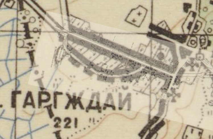
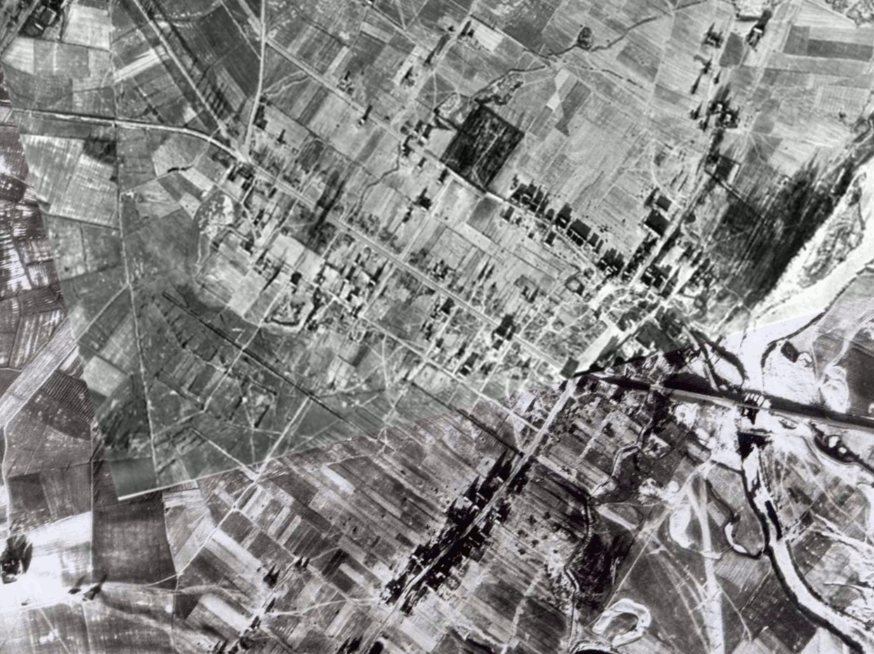
Comparison of Aerial Photos with Diagram of 1939 Fire
Further information about the location of the religious
buildings comes from a surprising source: a periodical entitled Die
Feuerlösch Polizei [The Firefighting Police], published in Berlin
on October 15, 1939. The magazine was directed to members of the
Firefighting Police throughout Germany and was under Nazi control; the
Firefighting Police had become a branch
of the Order Police (ORPO) in 1938. The issue contains an article
about the Garsden (Gargzdai) fire of August 15, 1939: "Ein halbes
Dorf vernichtet" (Half a village destroyed). The article
relates how firefighters from Memel crossed the border to help
extinguish the disastrous fire, which had spread to the extent that it
was beyond the capabilities of the local volunteer fire brigade.
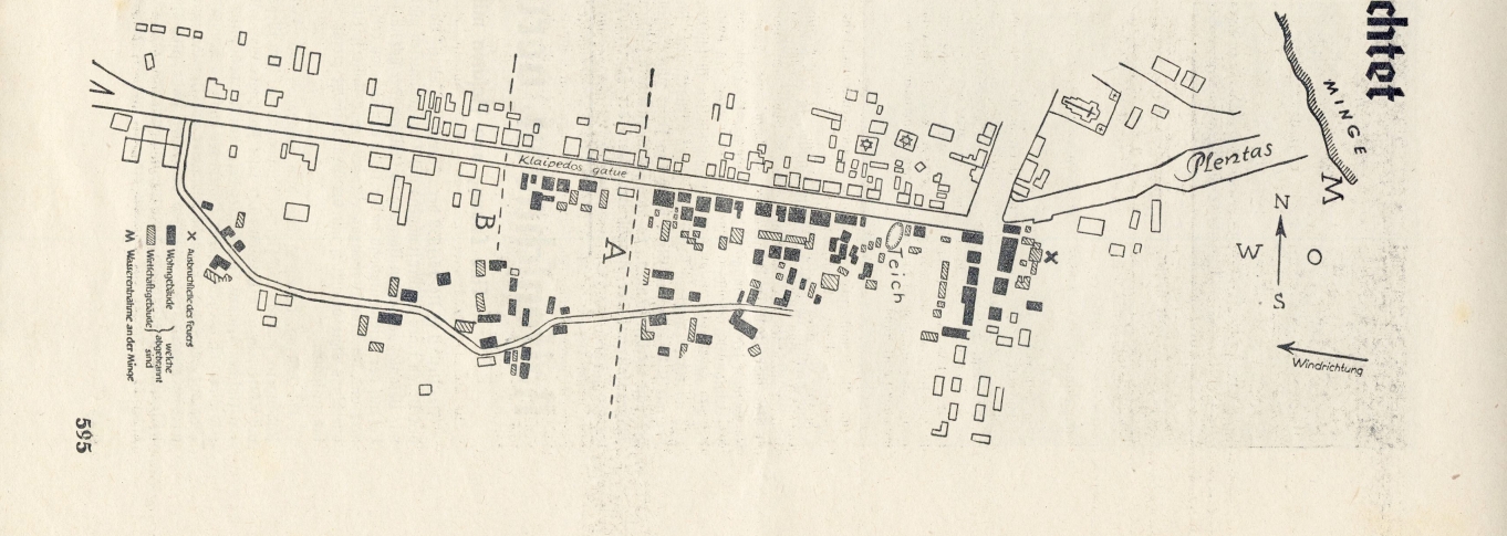
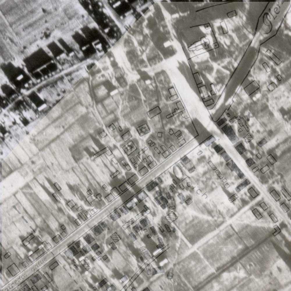
The article contains a detailed map showing location of burned dwellings
(filled in solid black) and burned commercial buildings (filled with
diagonal lines.) This map was evidently based on a pre-existing
town map of local origin. The visiting firefighters would not have
had time to construct such a detailed diagram, which would likely be
based on surveys or aerial photos. There are some other clues on
the map of alteration from an earlier source. The somewhat
distorted "G" on the "MINGE" River may show an overprint to change the
Lithuanian name MINIJA. Also the different languages and lettering
styles may indicate a map composed and completed at different
times. The word "Plentas" (Lithuanian for road or highway) is
written in elegant script, which may be contrasted with the more crudely
lettered "Teich"(German for pond). The pond is discussed in the
article: It was initially used as a water source in attempting to put
out the fire, but when the pond proved inadequate, water was then pumped
from the river.
Fire Map
Whatever its ultimate source, it is possible to achieve a
good match between the fire diagram and aerial
photo #157. Lining up the photos and diagrams is a somewhat
subjective process. One possible match is shown below. The Jewish
stars on two buildings mark the locations of the two synagogues, and
support their location as derived from the new synagogue plans and
aerial. The longer building to the west of the old synagogue
matches the size of the rabbi's residence and school shown in the plans
(though farther to the west, and with an addition to make an L-shape
from the originally designed rectangle).
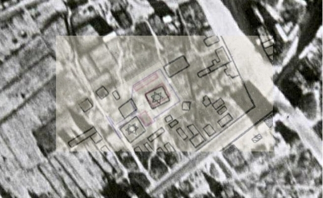
The diagram of the fire contains at least one error. The destroyed buildings at the east end of Klaipedos Gatve which would be visible from the street are marked as residential. The photographs of George Birman (here) and (here) show that the building visible at the end of the street was a pharmacy. Another discrepancy is that the diagram of the fire apparently does not show the Evangelical church (shown in maps here, here and here) as one of the destroyed buildings. The diagram of the fire does not indicate that any of the destroyed buildings was a church. The maps appear to locate the church farther south than any of the buildings marked as destroyed on the diagram of the fire. (It is difficult to locate the church with precision on the maps. Shown below is the fire diagram combined with the Russian map of 1910, which shows the cross marking the Evangelical church as further south than any of the burned buildings. The Catholic church on the fire diagram matches almost exactly the symbol on the Russian map, although the synagogue symbols may not be as closely aligned.) Janina Valanciute, Gargzdu miesto ir parapijos istorija, Vilnius: Diemedzio Leidykla, 1998 (ISBN 9986-23-047-0), p. 505 indicates the Evangelical church was destroyed in the fire.
The article contains statistics about the town and
fire. It states Garsden had approximately 3000 inhabitants, with
328 dwellings and approximately 350 commercial buildings. The
fire destroyed 103 dwellings and 150 commercial buildings, and left
1200 people homeless.
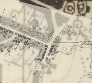
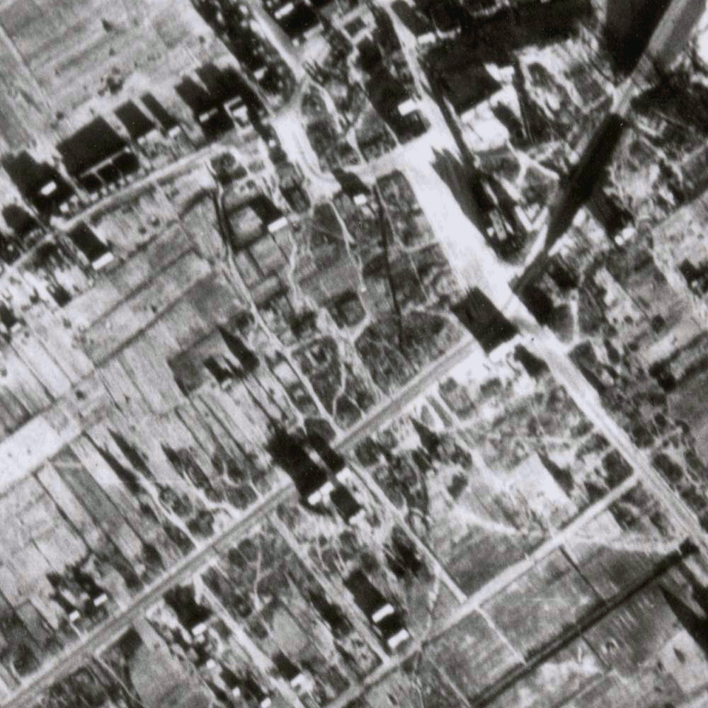
Animated comparisons between the fire diagram and aerials are shown below. The .gif animations may not be visible in some browsers and operating systems. The first animation is a comparison between the fire diagram, and a blended version of aerial # 157 and aerial #158.
The second animation enlarges the market area, and compares the fire diagram with a portion of aerial #157.


| Date |
Source |
Cause |
Destruction
includes: |
| 1786 |
J. Valanciute, Gargzdu miesto ir
parapijos istorija, Vilnius: Diemedzio Leidykla, 1998 (ISBN 9986-23-047-0), p. 500 Klaipedos Apskrities [history of fire department in Gargzdai, formerly online at http://www.vpgt.lt/gargzdai.pgt/index.php] |
Most buildings on Basanaviciaus St and
Catholic church. Following fire, town location shifted
northward, closer to the Estate. "severely hit by big fire" |
|
| August 25, 1895 |
A.
Chayesh, Box-Tax Paperwork Records as a Source of
Information, Litvaksig Online Journal (addendum 1) |
damages of 3009 rubles |
|
| 1915 |
Valanciute, p. 503 Pinkas Hakehillot Lita (Gorzd) Assif-Mendelson and Matalon-Mendelson, Gorzd Memorial Book, p. 69 (English section) Y. Glick, Gorzd Memorial Book. p. 287 (Hebrew/Yiddish section) Dr. H. Meyer, Gorzd Memorial Book, p. 63 (Hebrew/Yiddish section) |
war |
most buildings in market place communal ledger burned in fire in WWI (contained "details about the beginnings of the community") Stoch family home burned down in WWI house burned out in WWI city "damaged by a bomb" [fire not specifically mentioned] |
| August 15, 1939 |
Pinkas
Hakehillot Lita (Gorzd) Birman picture Valanciute, p. 505 Die Feuerlösch Polizei [The Firefighting Police], Berlin, Oct. 15, 1939 A. Orensteyn, Gorzd Memorial Book, p. 78 (Hebrew/Yiddish section) Klaipedos Apskrities |
industrial accident |
150 houses, half of the Jewish homes photo shows destroyed pharmacy 2/3 of town; Evangelical church, municipal building 103 dwellings and 150 commercial buildings, 1200 people left homeless 150 houses, 150 families left homeless 253 buildings, 250 families left homeless |
| June 22, 1941 |
Dr.
H. Meyer, Gorzd Memorial Book, p. 38 (English
section) Valanciute pp. 507; 420 (photo) Gorzd Memorial Book, p. 76 (English section) (Ulm proceedings) Klaipedos Apskrities |
war - set by Nazis Germans set fire because one soldier shot "fire broke out" between 10 and 11 AM |
almost entire town, including synagogue and Catholic church "many houses were razed to the ground" 164 houses and 18th century church. As of Dec. 1941, 363 persons from 138 families still homeless |
Identification of Features on Aerial Photo | Aerial Photo of Gargzdai