

Varangian (Viking) Routes (AD 800)
The River Berezina was part of an overland route used by Scandinavian Vikings who traded with the Khazarian Khans and Byzantine cities on the Black Sea coast. It is possible that the town of Byerazino began as a trading post on this route. The painting is by Russian artist Nicholas Roerich (1901). A map showing the principal Varangian routes is included in this Wikipedia article: https://en.wikipedia.org/wiki/Trade_route_from_the_Varangians_to_the_Greeks
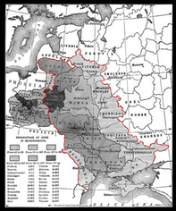
On this map, the gubernia are shaded to show the percentage of Jewish subjects in each. It illustrates a Wikipedia article about the Pale - a part of the Russian Empire where Jews were required to live from 1793 until the end of WWI: https://en.wikipedia.org/wiki/Pale_of_Settlement
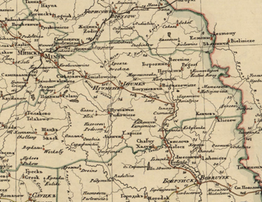
A military map of the Minsk province, with both Russian and Latin labels.
Source: World Digital Library https://www.wdl.org/en/item/2587/
Map of the Minsk Gubernia 1834
Source: JewishGen Belarus Special Interest Group http://www.jewishgen.org/Belarus/lists/1834_minsk_gubernia_map.htm
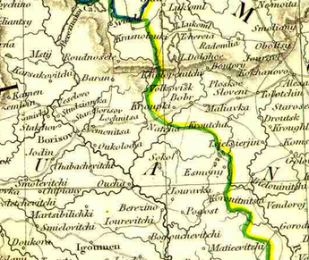
The scale of this map provides a good overview of the gubernia and its principal shtetlekh. It also shows the Berezinskoi Canal, feeding into the River Berezina north of Borisov. The Berezinskoi Water System streamlined the old Varangian route, thus allowing goods to be shipped between the Baltic and Black Seas via the River Berezina. This map is one of many helpful resources on the website of the JewishGen Belarus Special Interest Group (SIG) http://www.jewishgen.org/Belarus/
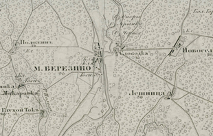
1866 Map of Igumen uyzd (in Russian)
In very fine scale, this online map shows the smallest of shtetlkh and supplies the names of minor streams and rivers not identified on the 1834 Minsk Gubernia map. The section (above) is centered on Byerazino. This map is very carefully drawn, yet is not over-decorated, so I prefer it to the 1915 German Military Map, which is basically a copy with additional topographical detail. The small numbers written under place names represent the number of ‘households’ registered in each town. This map and the 1915 version come from a wonderful online collection of maps and articles, titled Topographic Maps of Eastern Europe: An Atlas of the Shtetl at http://easteurotopo.org/
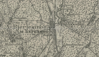
1915 German Military Map of Igumen uyzd
In preparation for the invasion of Russia, the German military acquired the 1866 Russian map of the Igumen district and transliterated the place names. They also added topographical marks to show details about roads and river crossings and suchlike. A set of detailed keys around the map’s margins explain these details (in German). However, the 1915 mapmakers did not update the ‘household’ count - the numbers that appear below the town names remain the same as on the map made half a century earlier.