
BIALYGen
Bialystok Region Jewish Genealogy Group
GRODNO GUBERNIYA POLAND IMAGING PROJECT
SURVEY OF JEWISH CEMETERIES
by Heidi M. Szpek, Ph.D.
Associate Professor, Department of Philosophy and Religion Studies
Central Washington University
May 2007
Partial funding provided by: The Department of Philosophy & The Office of International Studies and Programs Grant Committee,
Central Washington University, Ellensburg, Washington 98926, USA
Back to Poland Imaging Project Cemeteries Index
|
Narewka GPS: 52°50'N 23°45'ESize: c. 2.5 acres Number of matzevoth: >100 (plus support structures) Bagnowka.com: Narewka Gallery (photographed in 2006)
Image 1
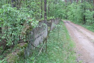
Directions: The cemetery is relatively easy to locate. From Bialystok, travel 16 km south on highway 19 to Zabludow. The highway will fork (with route 19 going southwest and route 685 going southeast). Go left onto route 685 for 35 km (you will pass through Narew about halfway). The road will again fork at Nowosady (south 685 to Hajnowka and north 687 to Narewka). Take 687 to Narewka. After crossing the Narewka River, take the first county road at right (east), heading to Guszczewine. The cemetery will shortly be on your left, with a grassy road before and a dirt road after the cemetery. Park on either roads and walk up into the cemetery. Or drive up the second dirt road which will take you to the back (= entrance to the cemetery), where the remains of a masonry wall still stand (Images 2, 3).
Conditions: The cemetery is surrounded by pine forest with varied vegetation (Image 1,4,5). Though one can enter on the east, at back (west) is the entrance with a broken masonry wall (Images 2,3). The majority of matzevoth are preserved in the central area – a hill that gently slopes toward the road (Image 6). Artillery fighting positions stretch out across the width of the cemetery at the slope just before the road; the cemetery is flanked by steep inclines on both sides (Image 7). The matzevoth are of varied styles (boulder, granite, obelisk), many legible and in situ (Images 1,5,8,9,10). The area is clear of litter, with the only visible threat being natural vegetation.
Back to Poland Imaging Project Cemeteries Index
|